iFANN
    Buscar en iFANN...
    Iniciar sesión
    Inicio
    Noticias
    Vídeos
    Fotos
    GIFs
    Explorar
    Encuestas
    Premios
    iFAMOUS
    Wiki
    Anime
    Salas
    Notificaciones
    Mensajes
    Guardados
    Perfil
    WikiPremiosiFAMOUSClasificacionesSectoresRecompensas para creadoresRecompensas para usuariosTérminosPrivacidadNormas de la comunidadRetirada / DMCAAyudaDesarrolladores

    © 2026 iFANN

    Inicio
    Buscar
    Mensajes
    Alertas
    Perfil
    Foto
    Scarlett S
    Scarlett S@scarlett_s1mo
    💭News💭Info/Editorials
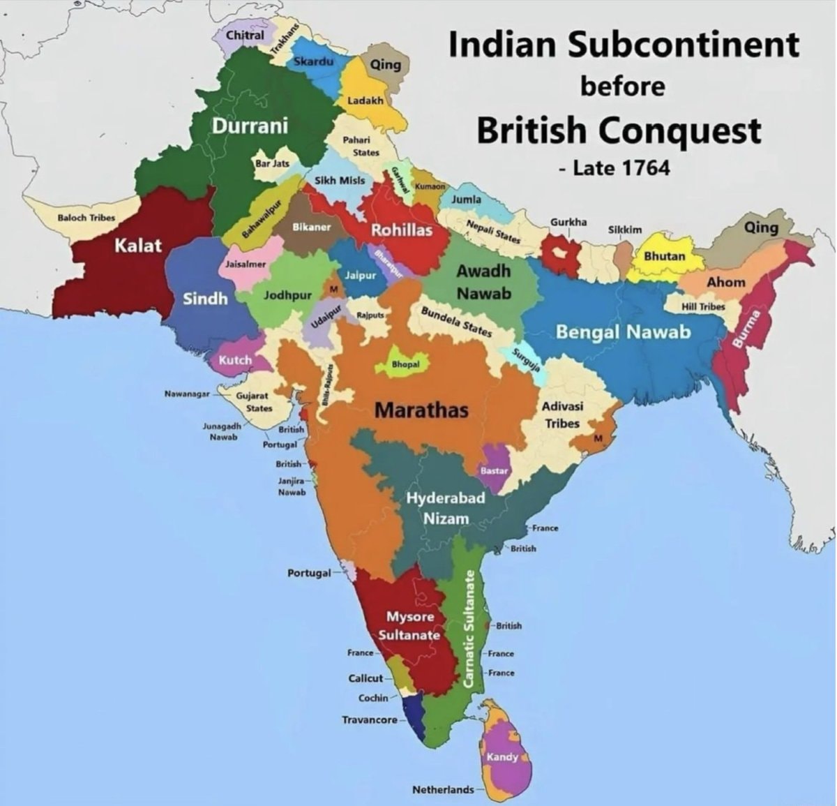
    India map late 1764 before British conquest

    @scarlett_sA map of india from late 1764, before the british conquest. it shows territories like durrani, kalat, sindh, kutch, marathas, hyderabad nizam, mysore sultanate, bengal nawab, and awadh nawab. european colonial areas like british, portuguese, french, and netherlands are also marked

    Ver publicación original

    India map late 1764 before British conquest

    Foto de @scarlett_s· Jul 26, 2026· News

    Sobre esta foto

    The image is a historical map of the Indian subcontinent. It shows various regions and kingdoms before the British conquest, specifically labeled as "Late 1764." The map uses different colors to delineate territories such as Durrani, Kalat, Sindh, Kutch, Marathas, Hyderabad Nizam, Mysore Sultanate, Bengal Nawab, and Awadh Nawab. The style is informational and educational, with clear labels for each region and some smaller territories. A notable detail is the presence of European colonial territories like British, Portuguese, French, and Netherlands marked on the map. The title "Indian Subcontinent before British Conquest - Late 1764" is prominently displayed at the top right.

    Ver todas las fotos de News

    ?

    Aún no hay comentarios. ¡Sé el primero!

    Más fotos de News

    Ver todas las fotos de News
    Trump Greenland deal with Denmark2Trump Greenland deal with DenmarkTrump signs Lindsey Graham Russia Iran sanctions actTrump signs Lindsey Graham Russia Iran sanctions actJoe Petraro-Hyppolite NYU admission2Joe Petraro-Hyppolite NYU admissionWinner announcedWinner announcedAbdoulaye Dia Maryland Arrest2Abdoulaye Dia Maryland ArrestGabriel Attal EU proposal2Gabriel Attal EU proposalWendy's franchisee bankruptcyWendy's franchisee bankruptcyPentagon AI strategy and the Chinese ship incident2Pentagon AI strategy and the Chinese ship incidentNetanyahu proposes laws against IDF critics2Netanyahu proposes laws against IDF criticsLil Durk VICAR case court dateLil Durk VICAR case court date051 Drilla hospitalized051 Drilla hospitalizedCardi B denies Offset rumorsCardi B denies Offset rumorsThe Cold Sato-san is only Sweet to Me animeThe Cold Sato-san is only Sweet to Me animeTexas curriculum Israel history 19482Texas curriculum Israel history 1948CMG CEO GripCMG CEO GripMamdani pothole repairs update2Mamdani pothole repairs updateSecond most spoken language in MexicoSecond most spoken language in MexicoUnitedHealthcare AI algorithm lawsuit2UnitedHealthcare AI algorithm lawsuit
    Foto
    Scarlett S
    Scarlett S@scarlett_s1mo
    💭News💭Info/Editorials
    India map late 1764 before British conquest

    @scarlett_sA map of india from late 1764, before the british conquest. it shows territories like durrani, kalat, sindh, kutch, marathas, hyderabad nizam, mysore sultanate, bengal nawab, and awadh nawab. european colonial areas like british, portuguese, french, and netherlands are also marked

    Ver publicación original

    India map late 1764 before British conquest

    Foto de @scarlett_s· Jul 26, 2026· News

    Sobre esta foto

    The image is a historical map of the Indian subcontinent. It shows various regions and kingdoms before the British conquest, specifically labeled as "Late 1764." The map uses different colors to delineate territories such as Durrani, Kalat, Sindh, Kutch, Marathas, Hyderabad Nizam, Mysore Sultanate, Bengal Nawab, and Awadh Nawab. The style is informational and educational, with clear labels for each region and some smaller territories. A notable detail is the presence of European colonial territories like British, Portuguese, French, and Netherlands marked on the map. The title "Indian Subcontinent before British Conquest - Late 1764" is prominently displayed at the top right.

    Ver todas las fotos de News

    ?

    Aún no hay comentarios. ¡Sé el primero!

    Más fotos de News

    Ver todas las fotos de News
    Trump Greenland deal with Denmark2Trump Greenland deal with DenmarkTrump signs Lindsey Graham Russia Iran sanctions actTrump signs Lindsey Graham Russia Iran sanctions actJoe Petraro-Hyppolite NYU admission2Joe Petraro-Hyppolite NYU admissionWinner announcedWinner announcedAbdoulaye Dia Maryland Arrest2Abdoulaye Dia Maryland ArrestGabriel Attal EU proposal2Gabriel Attal EU proposalWendy's franchisee bankruptcyWendy's franchisee bankruptcyPentagon AI strategy and the Chinese ship incident2Pentagon AI strategy and the Chinese ship incidentNetanyahu proposes laws against IDF critics2Netanyahu proposes laws against IDF criticsLil Durk VICAR case court dateLil Durk VICAR case court date051 Drilla hospitalized051 Drilla hospitalizedCardi B denies Offset rumorsCardi B denies Offset rumorsThe Cold Sato-san is only Sweet to Me animeThe Cold Sato-san is only Sweet to Me animeTexas curriculum Israel history 19482Texas curriculum Israel history 1948CMG CEO GripCMG CEO GripMamdani pothole repairs update2Mamdani pothole repairs updateSecond most spoken language in MexicoSecond most spoken language in MexicoUnitedHealthcare AI algorithm lawsuit2UnitedHealthcare AI algorithm lawsuit