@scarlett_sThe U.S. actually has forest biomass
Ver publicación original@scarlett_sThe U.S. actually has forest biomass
Ver publicación originalFoto de @scarlett_s· Sep 3, 2026· United States
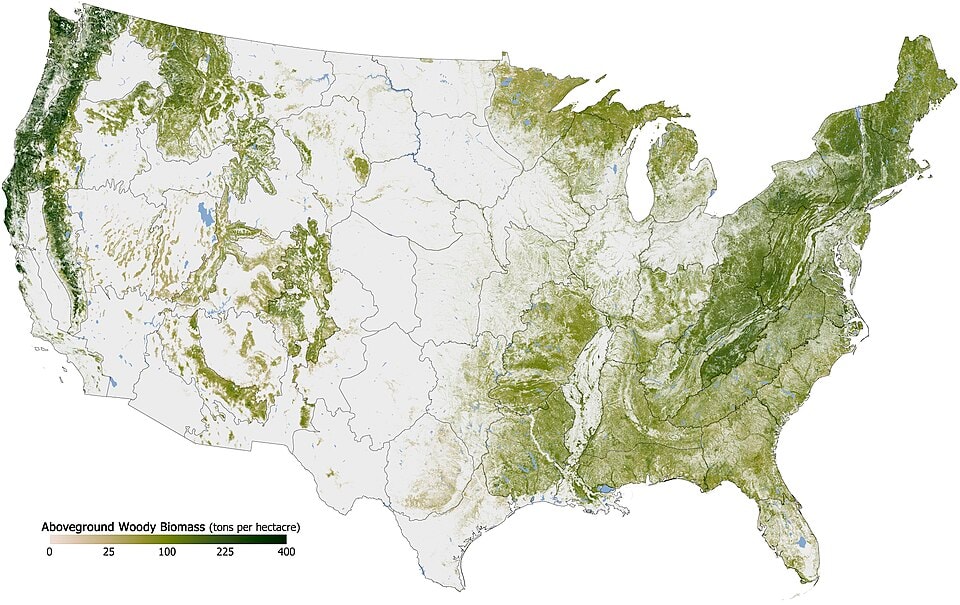
The image is a map of the United States showing aboveground woody biomass. Different shades of green indicate varying amounts of biomass per hectare, with darker greens representing higher concentrations. A legend at the bottom left provides a scale from 0 to 400 tons per hectare. The map's style is informational and scientific, highlighting geographical data. The most notable visual aspect is the clear depiction of dense forests along the Pacific coast, in the Appalachian Mountains, and parts of the Southeast.
 Peacham United States autumn landscape
 Stowe United States
 CDC reports congenital measles cases in US newborns
 US counties without a McDonald's
 2US to vote no on killer robots ban
 Juniper Networks router FAA outage
 US State population under 25 share
 2Backpack crypto exchange logo
 Immigrant population map by state
 2New York Stock Exchange outage
 Tallest men by U.S. state map
 Lisa Google Trends US search map
 2Kristin Logan Canada assisted suicide US surgery
 Miami airport plane collision
 CIA Galápagos drone program secrecy
 2US probe into Nvidia AI chip sales to China
 United States location
 Thomas Massie Iran war House vote
@scarlett_sThe U.S. actually has forest biomass
Ver publicación originalFoto de @scarlett_s· Sep 3, 2026· United States
The image is a map of the United States showing aboveground woody biomass. Different shades of green indicate varying amounts of biomass per hectare, with darker greens representing higher concentrations. A legend at the bottom left provides a scale from 0 to 400 tons per hectare. The map's style is informational and scientific, highlighting geographical data. The most notable visual aspect is the clear depiction of dense forests along the Pacific coast, in the Appalachian Mountains, and parts of the Southeast.
Peacham United States autumn landscapeStowe United StatesCDC reports congenital measles cases in US newbornsUS counties without a McDonald's2US to vote no on killer robots banJuniper Networks router FAA outageUS State population under 25 share2Backpack crypto exchange logoImmigrant population map by state2New York Stock Exchange outageTallest men by U.S. state mapLisa Google Trends US search map2Kristin Logan Canada assisted suicide US surgeryMiami airport plane collisionCIA Galápagos drone program secrecy2US probe into Nvidia AI chip sales to ChinaUnited States locationThomas Massie Iran war House vote